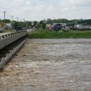
The hurricane season has kicked off at the Meadowlands bringing a different, still just as serious threat that COVID-19 has graced us with. MERI scientists have been equipping strategic tide gates in the Hackensack River estuary to predict flooding caused by storm surge in the 14 towns of the Hackensack Meadowlands District.
These self-sustaining stations are equipped with Campbell Scientific’s CR300 data loggers explicitly designed for long-term remote monitoring and powered by solar panels. The built-in Wi-Fi option ensures instant communication with MERI’s environmental server. It has also allowed us to build a real-time alert system (https://meri.njmeadowlands.gov/alerts/water-level/), that would trigger an alarm whenever the water level reaches 4.5ft at the riverside. At that point, a text message goes out to the subscribers to prompt them to monitor the progress of the storm, should the water level further increase, and the risk of flooding arise. Also on this page, static flood risk maps provide further information on potential flood hazards for each of the 14 municipalities. Subscription is free upon request.
The water depth data is also displayed on MERI’s website powered by VISTA Data Vision (https://vistadatavision.com/). Graphs for each tide gate show the changes in water level and temperature every 15 minutes. The charts update hourly, and can be viewed by the public. The current data – up to a calendar year – is available for download from the website by hovering over the “Scientific Data” menu in the navigation bar and selecting “Environmental Monitoring Data”. Historical records may be requested.
Please refer to the thematic map for locations of the tide gauge sensors included at: https://meri.njmeadowlands.gov/wp-content/uploads/2020/07/map.jpg. Click on the embedded site map photo to view the full resolution of the site map.
For more information, visit: https://meri.njmeadowlands.gov/events/